In 1763, by the Treaty of Paris, France relinquished to England all claim on Canada. In the same year, the English issued a proclamation conceding to the Indians the right of occupancy upon their old hunting grounds and their claim to compensation for its surrender. In accordance with this policy, the English government treated for and obtained in 1784 a formal cession of the tier of townships now fronting on Lake Ontario from Toronto east to Trenton. This satisfied the land-hunger of Anglo-Saxon colonists for more than three decades, but its area was not permanently adequate. At last, on November 5, 1818 the chiefs of the six Mississaga tribes, Buckquaquet of the Eagles, Pishikinse of the Reindeers, Paudash of the Cranes, Cahgahkishinse of the Pike, Cahgagewin of the Snakes, and Pininse of the White Oaks, were summoned to Port Hope. There they sold to the Crown a great block of land comprising the modern counties of Peterborough and Victoria, and twenty-eight adjoining townships or parts of townships in Hastings, Northumberland, Durham, Ontario, Muskoka and Haliburton. For this tract, comprising well over two million acres, the purchase price was set at Ł740 in goods to be delivered yearly forever to the Mississaga tribes of the district. After this contract had been signed, however, the Deputy Superintendent General of Indian Affairs added a strange postscript announcing that the government proposed to issue only $10 in goods annually to each man, woman and child alive at the time of the sale. This payment would cease with their death; and individuals born after November 5, 1818 would receive nothing. Thus, by a stroke of chicanery, fifty-seven Ontario townships passed to the white man for a brief dole of merchandise. (See "Indian Treaties and Surrenders," Vol. I, page 49, published by the King's Printer, Ottawa.)
The Story Of A Town
By Jane Staunton.
from The Evening Guide, March 6, 1984 - page 3.
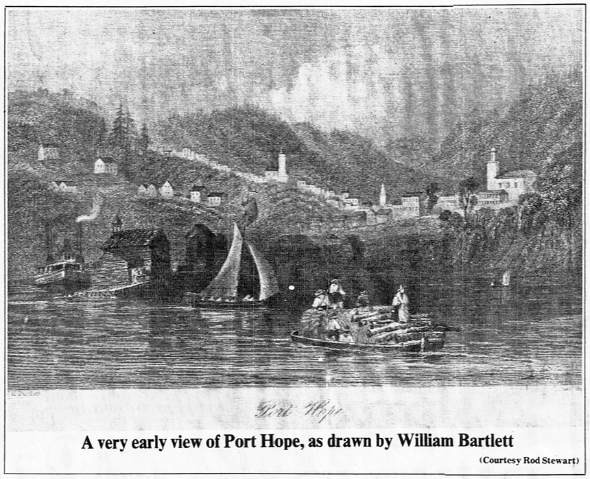
Ganaraske, - Pimidaichekontoyng, - Fat Fire Creek, - Pemitescutiang, - Cochingomink, - Hope Mills, - The Flats, - Smith's Creek, - Toronto, - from 1660 to 1819 these names - French, Indian, and English - referred to the same site, the tiny settlement on the banks of a shallow swift-flowing creek, which emptied into a natural harbour, on the north shore of what came to be called Lake Ontario. From 1819 to the present day, the town has been called Port Hope.
Aboriginal Settlement.
The Port Hope site and surrounding townships are situated on a clay plain, with a limestone base, which was created when the ancient Lake Iroquois receded to the boundaries of the present Lake Ontario. These clay-silt plains formed extremely rich growing soils, later discovered to be particularly suitable for grain and fruit crops. The river teemed with trout, and salmon, and the heavily forested country surrounding the river abounded with birds and small game.
The first known inhabitants of this location, so rich in natural resources, were a band of Huron Indians, the Cayugas, who hunted trapped and fished the area in the early 17th century. However, small groups of warlike Iroquois began to raid the Hurons, making life so unsafe, that by 1630 the last of the Cayugas had retreated to the north shore of Lake Huron. Although the victorious Iroquois did not settle here until the
mid 1660s, they used the area extensively for fishing, hunting and trapping, trading their furs with the English and French, who had established trading posts on the Hudson River.
The French Regime.
It is unlikely that any French explorers, English, Dutch or French traders had discovered the area before the Iroquois conquest, but after Canada became a Royal Province of France in 1663, the French made plans to recapture the fur trade from the Iroquois, who had established themselves here in the little settlement of Ganaraske. In the late 1660s, the Sulpicians of the Mission of Kente, in Montreal, founded missions under the leadership of Father D'Urfe here, and at other Indian settlements along the north shore of the Lake. On a French map dated 1673, the tiny habitation of Ganaraske is marked. Perhaps the earliest existing map depicting this site. The next to arrive here were Mississauga Indians, a tribe of the Algonkian family. Although a less advanced race than the Iroquois, they took over the settlement, and the Iroquois gradually disappeared to other regions. The Mississauga village on the east bank of the river was
named Cochingomink, meaning "the commencement of the carrying place", and referring to the route from the river mouth north through the forest, and sand hills, to Rice Lake. During the last 50 years of French rule, there were three Indian settlements along the carrying-route to the interior.
The British Rule.
In 1763, by the Treaty of Paris, Canada became a British Crown Colony. Twelve years later the American Revolution began. Both were events which were to alter the complexion of the hitherto relatively quiet and unchanged hunting grounds of Ganaraske, and begin the process which would propel Upper Canada into being, and Port Hope into an important centre.
During the American Revolution, subjects loyal to the British Crown fled the Thirteen Colonies, their property and belongings confiscated and their lives in danger. Thousands flocked to Fort Niagara, on British territory, to wait for peace to be declared and a return to there homeland as promised by the British government. However, events of history dashed there hopes when the British garrison of Fort Niagara was surrendered to the Americans and American independence was proclaimed. However, the British government, anxious to colonize its immense land
holding, gained by the Treaty of Paris, encouraged the Loyalists to settle Upper Canada with promises of extensive land grants.
The village of Cochingomink had already been discovered by a handful of Loyalist traders and trappers, and as early as the decade of the 1770s, trading houses had been established at this site and others, along the north shore of the Lake.
Richard Beasely and Peter Smith, Loyalist traders, requested from the Government Land Committee grants of land, both at Toronto and the Ganaraske site, which they referred to as Pemitiscutiank, meaning "Fat Fire Creek." In their petition to the government, they mention that they had built a log dwelling at each site - in Pemitiscutiank, on the east shore of the river mouth. Peter Smith was a trapper of some skill and had built a reputation among the Indians of honesty and fair dealing by the time the Indian Treaty of 1788 opened up the Ganaraske area to white settlement. By this time the area was referred to by the English name of Smith's Creek, and this was the name heard by the Loyalists waiting in Newark to be resettled.
In 1790, Smith turned over his trading post to brothers Lawrence, and Jacob Herchimer, also spelled Herchmer and Herkimer), purportedly also Loyalists, who had managed to escape the U S, and eke out a living in the Canadian wild, without the land and provisions enticements of the British Government. The Herchimer brothers, carried on the respected position and honest dealings established by Smith and Beasely, with Indians from all over the Kawartha Lakes region.
The Constitutional Act of 1791 provided the first real impetus to Canadian pioneering, and the new Legislative Assembly became very active in encouraging settlers to come to Upper Canada.
Two enterprising gentlemen, both United Empire Loyalists and officers. Elias Smith, then a merchant of Montreal, but formerly of Dutchess County New York, and Captain Jonathan Walton of Poughkeepsie New York, had visited the site of Cochingomink, (or Smith's Creek), as early as 1792. And, in an agreement with Simcoe's government, they began recruiting settlers for Hope township, named for Colonel Henry Hope, Lieutenant-Governor of Quebec, from 1785 to 1789. The agreement entailed the permanent settling of 40 families in return for extensive land grants.
The first Smith and Walton boatload of 27 Loyalist settlers arrived from Newark on June 7, 1793 at Cochingomink, to be met on the Shore by a Herchimer brother and several hundred Mississauga Indians. Accounts of the arrival by a descendant of one of the four original Hope township families report that the Indians were suspicious of and hostile to the new arrivals, suspecting them to be yankees, until Herchimer reassured them of their common loyalty to the Great White Father. A peaceful welcome ensued.
The four families - Harris, Stevens, Ashford and Johnston - slept their first night at Cochingomink in tents, and proceeded the next morning to begin building their first permanent homes on Canadian soil.
Shortly afterwards. Lawrence Herchimer returned to Kingston, becoming a merchant and one of the builders of the first steamboat on Lake Ontario, the Frontenac. Jacob Herchimer moved north to establish a trading post at the mouth of the Otonabee River.
In Elias Smith's report to Governor Simcoe of the safe arrival of the four families, totaling 27 people, to Hope township, he writes that there is no one nearer than 50 miles on one side, and 60 to the other, and adds that he has furnished the new settlers with provisions for a year at his own expense - this all serving as a reminder to the governor of the promised grant of and if the township were settled.
By 1797, Smith and Walton had installed their required 40 families and on October 8 of that year, by order in council, they were given a Crown Patent for Lots 5, 6 and 7 of the Broken Front and First Concession of Hope township, totaling 727 acres including road allowances of 103 acres. It was with this Crown grant that the settlement of Smith's Creek became definitely established, and the development of a town could begin in earnest.
Use the form below to comment on this article. A name is required, optional email address will not be revealed.